I heard earlier today that the Kilauea volcano may be about to explode. I took that to mean that the top might be blown off and major devastation happen to the island.
As far as flying there, . . . it's too hot for me! I'd hate to be the first hang glider pilot to fall to the ground Pompeii style. That is, a crispy pod harnessed body encased in solidified lava. Yikes!!!!
wingspan33 wrote:I heard earlier today that the Kilauea volcano may be about to explode. I took that to mean that the top might be blown off and major devastation happen to the island.
Hawaiian volcanos generally do not blow off their top. Their lava is rather fluid and tends to just flow freely from crevasses.
Well Kia, it looks like you are right. There's something about gas bubbles in the lava that helps cause the explosive nature of an eruption. And Hawaiian volcanoes don't typically have these. But I've also read that an expert has noted that "However, Kilauea has experienced violent explosive eruptions in the past, . . . including several from roughly 1500-1800."
I hope that all we see are lava flows. Heck, maybe catching a thermal over Kilauea wouldn't be so bad after all!
Not to worry... Mauna Loa is the largest and highest mountain in the world, rising about 55,000 feet from the sea floor. What could go wrong?
The current eruption of Kilauea volcano on Hawaii's Big Island is accompanied by thousands of earthquakes. Most of them have magnitudes below 2.5, but some of them are significantly bigger. However, not all of them are created equal. To investigate the nature of the various earthquake sequences, let's look at an impressive time lapse animation of the seismicity under the south-east corner of the Big Island over the last week. This animation was put together by the scientists at the Pacific Tsunami Warning Center (PTWC) in Honolulu. The underlying map in the video in Figure 1 shows the inactive Moku'aweowoe summit caldera of Mauna Loa on the left right below the logo of the PTWC. The Kilauea summit is the circular depression in the middle of the map. From there the volcano's East Rift Zone is seen on the right. It extends all the way to the eastern tip of the Big Island. The southern coast is dominated by a steep cliff, called "pali" in Hawaiian.
Each quake is represented by a dot on the map at its epicenter. The bigger the dot, the larger the magnitude of the quake. The animation starts last Monday (April 30th) at noon local time. During the animation, the clock at the upper right of the map shows the elapsed time. Initially the quakes' epicenters cluster around the middle of the rift zone. Over the next three days they slowly move towards the east. This migration of the earthquake foci indicates the underground movement of magma away from the volcano's summit. At around 1 pm on May 3rd, a significant yellow dot appears near the coast in the middle of the rift zone. This magnitude 5 earthquake seems to have shaken up the magma in Kilauea's plumbing system, because a couple of hours later, the first fissures opened up near the eastern end of the rift, about 25 miles from the summit. This is indicated by the yellow star and the word "eruption" that shows up in the animation. For the next 24 hours the seismicity is concentrated under the eruption, during which more and more lava-spewing fissures opened in the Leilani Estates subdivision of the Puna District. This is again indicative of magma movement under the eruption center. The picture changes completely shortly after noon on Friday, May 4th. A huge earthquake with a magnitude of 6.9 rocks the entire island chain, indicated by the large orange dot on the map. This is strongest quake to have rattled Hawaii in 43 years. It triggers a lot of additional seismicity away from the eruption center. The new seismic events cluster under the Kilauea summit as well as along the cliff. While the earthquakes under the summit and under the eruption center at the eastern end of the rift zone are generated by the movement of magma, the big event and its aftershocks under the pali have a different origin. This becomes obvious in Figure 2.
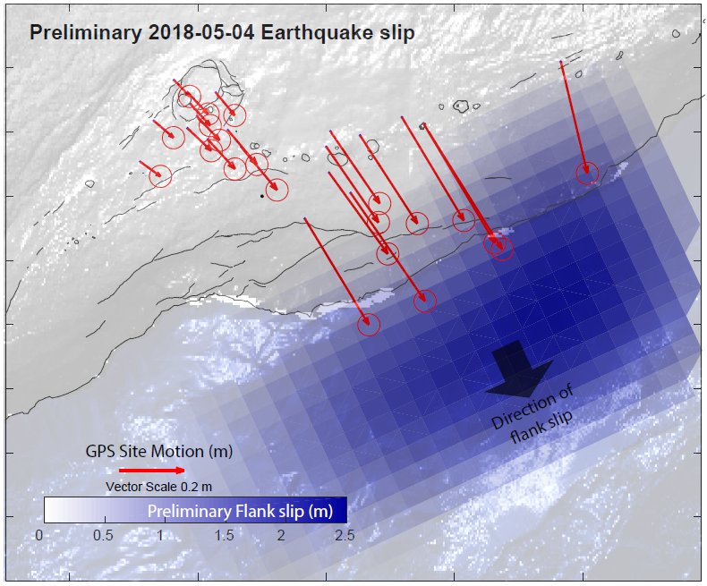
It shows how the permanent GPS stations installed and operated by the Hawaii Volcano Observatory moved in response to the 6.9 quake. The red arrows indicate the direction of horizontal motion and all of them point to the southeast. The length of each arrow represents the extent of the motion with the longest ones having moved by more than 2 feet. This shows that the flank of the cliff on the southern coast of Hawaii has moved further towards the ocean.
This type of motion is not new, it actually has a name. It is called the Hilina Slump. During the last strong quake in Hawaii, a magnitude 7.2 event on November 29th 1975, this slump slid toward the ocean by about 11 feet. Another temblor, the 7.9 magnitude Hawaii quake of 1868 caused the slump to move as well, resulting in a tsunami with a maximum wave height of about 60 feet.
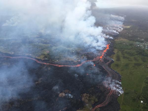
With all respect for the people who are being affected by the current eruption, the way Kilauea lava comes to the surface is rather tame. It crawls slowly along the ground and one can easily outpace it at a leisurely walk. In this sense, the ongoing eruption is a slowly developing emergency, which gives people enough time to react and take shelter.
A complete failure of the cliff at the southern side of Hawaii along the extensional Hilina Fault system, however, would generate a huge, sudden disaster. It is estimated that about 10 percent of the island’s total volume could be affected by the collapse. The huge slide could generate a magnitude 9 quake, which is comparable to the largest earthquakes ever measured. It would also generate a megatsunami with an estimated wave height of more than 1000 feet throughout the islands. Geologic records show that about 110,000 years ago, long before any of the adventurous Polynesian seafarers had reached the island chain, Hawaii was rocked by such a slump and engulfed in the resulting huge tsunami. However, a repeat of such a rare catastrophic event is highly unlikely and it may take many millenia for it to occur.
-- Berkeley Siesmology Laboratory A Slow Emergency and a Sudden Slump, May 7, 2018