Personal Journals about Hang Gliding

Re: Global Meteorology for Hang Glider Pilots

Postby Bob Kuczewski » Wed Sep 27, 2017 11:17 pm

Those are some shocking stories!    :shock:

It's great to see you here, Red!!    :thumbup:
Join a National Hang Gliding Organization: US Hawks at ushawks.org
View my rating at: US Hang Gliding Rating System
Every human at every point in history has an opportunity to choose courage over cowardice. Look around and you will find that opportunity in your own time.
Bob Kuczewski
User avatar
Contributor
Contributor
 
Posts: 8966
Joined: Fri Aug 13, 2010 2:40 pm
Location: San Diego, CA

Re: Global Meteorology for Hang Glider Pilots

Postby Rick Masters » Sun Jan 07, 2018 10:51 am

Image

GOES-16 now operational in geosynchrous orbit!
    Now in its new GOES-East position, the advanced GOES-16 satellite has officially joined NOAA’s operational observation network, providing forecasters with sharper, more defined images of severe storms, hurricanes, wildfires and other weather hazards in near real-time 24/7.
    You can view the latest, stunning imagery from GOES-East via NOAA's new GOES-East Image Viewer. The Viewer provides "full disk" views of Earth (covering the Western Hemisphere) as well as views of the continental US and adjacent waters (CONUS). Finally, the viewer also provides "mesoscale" imagery--views of small regional or areas that can help reveal significant environmental features.
    Visitors will be able to access and download still images as well as animated sequences of imagery covering several hours.
        -- NASA

Click here for the live view from GOES-16
https://www.star.nesdis.noaa.gov/GOES/index.php

That little white spot near Santa Monica is frank's 330 Condor.
Rick Masters
Contributor
Contributor
 
Posts: 3260
Joined: Fri Jul 15, 2011 5:11 am

Re: Global Meteorology for Hang Glider Pilots

Postby Rick Masters » Mon Jan 22, 2018 11:25 pm

On January 15, 2018, this plane
Image
a Boeing 787-9 Dreamliner set a record for a subsonic aircraft crossing the Atlantic.
It flew from New York to London in 5 hours 13 minutes, reaching ground speeds of up to 776 mph.
The day before, another plane had made the same run in 5 hours 20 minutes.
How was it possible for a subsonic passenger plane to make that kind of time?

Image
The heart of the northern cold has shifted from the Arctic Ocean to Hudson's Bay.
The circumpolar winds used to flow in a fairly tight circle around the North Pole at zero latitude.
Now, with the heart of the cold over Canada, the Coriolis Effect is messing with the circumpolar winds and forcing them to spin much farther south than they used to.
They get all wiggly and wavy, too, and sometimes they get lost and trickle out.
Overall, they've slowed down significantly.
But occasionally the bands tighten up and get screaming.
That's what happened on January 15. The strongest winds were clocked at 264 mph.
You can see the jet stream band (use ctl shift - to shrink the image) on the right.
That's the band on the day the Dreamliner flew so fast to London.
In addition to getting to London faster, changes in a planet's Polar Vortex is a big deal by any measure.
This is likely to have other effects and we're all part of the experiment.     :o
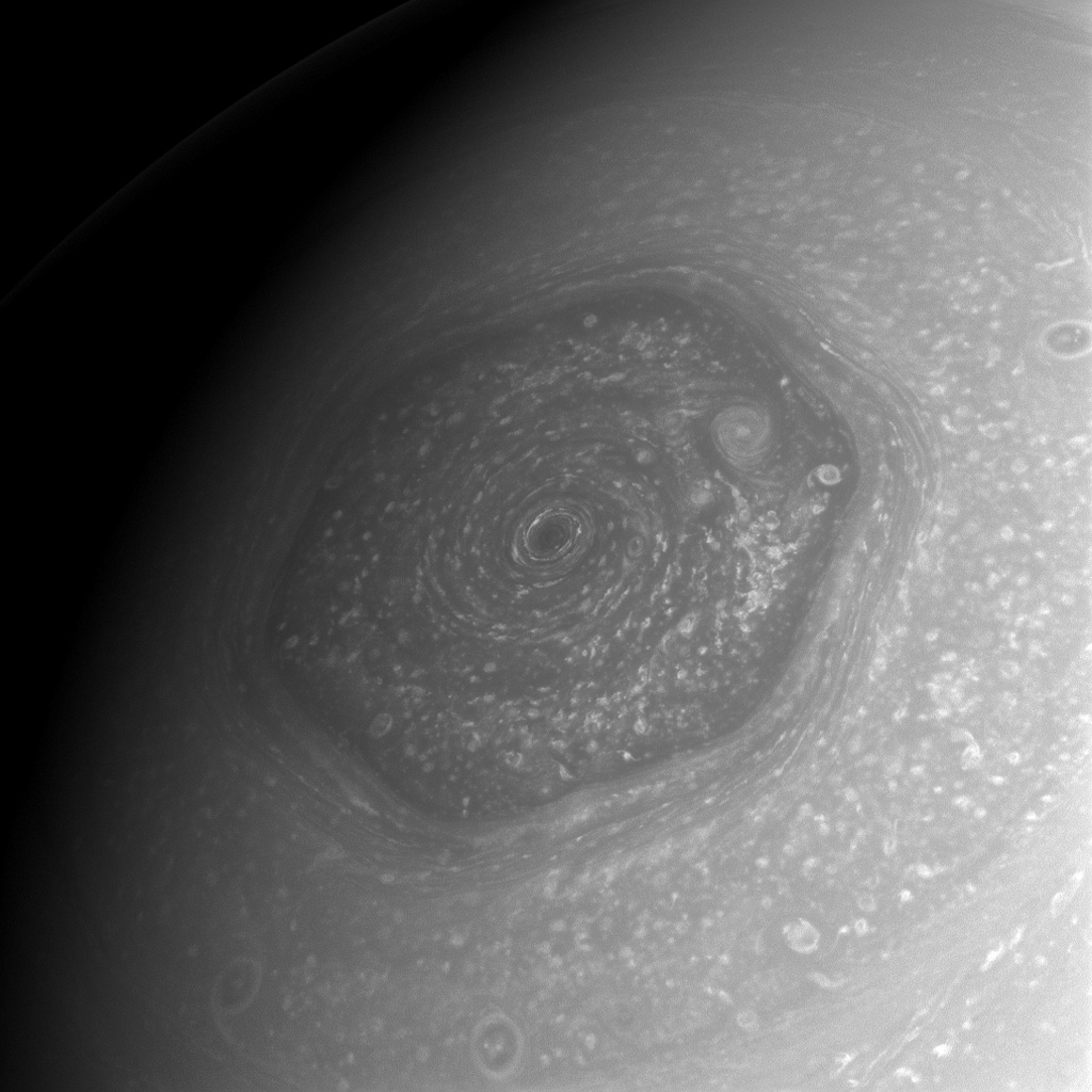
Here's Saturn's Northern Polar Vortex, perfectly centered around zero latitude, for comparison.
Yeah, it really is a hexagon. Freaky, huh?

Image
Image
Rick Masters
Contributor
Contributor
 
Posts: 3260
Joined: Fri Jul 15, 2011 5:11 am

Re: Global Meteorology for Hang Glider Pilots

Postby Rick Masters » Sun Feb 18, 2018 10:48 am

Using Cameron Beccario's >earth<
Image

A visualization of global weather conditions forecast by supercomputers - updated every three hours.
Ocean surface current estimates - updated every five days.
Ocean surface temperatures and anomaly from daily average (1981-2011) - updated daily.
Ocean waves - updated every three hours.

https://earth.nullschool.net/#current/wind/surface/level/orthographic=-117.76,38.74,3000/loc=-121.099,36.449
Press F11 for full screen
Use mouse wheel for zoom

Keystrokes
e show the menu
escape close dialog/menu
k go forward one time step
shift-k go forward several time steps
j go backward one time step
shift-j go backward several time steps
n go to now (the most recent data)
i go up one pressure level
shift-i go up to the stratosphere
m go down one pressure level
shift-m go down to the surface
g toggle the grid on/off
p toggle the animation on/off
shift-h enable/disable high definition mode

Tutorial


Paul Beckwith
Rick Masters
Contributor
Contributor
 
Posts: 3260
Joined: Fri Jul 15, 2011 5:11 am

Re: Global Meteorology for Hang Glider Pilots

Postby Rick Masters » Mon Feb 19, 2018 8:16 pm

On the planet I grew up on, I could find the circumpolar vortex by looking at the winds circling the polar regions.
Not any more. This can't be good. Good luck, humanity. You're going to need it.
https://earth.nullschool.net/#current/wind/isobaric/250hPa/stereographic=10.87,126.93,335/loc=63.894,-5.479

Hurricane warning
https://www.facebook.com/EarthWindMap/videos/2058848194348900/
Rick Masters
Contributor
Contributor
 
Posts: 3260
Joined: Fri Jul 15, 2011 5:11 am

Re: Global Meteorology for Hang Glider Pilots

Postby Rick Masters » Thu Mar 01, 2018 2:27 pm

Bombogenesis

Bombogenesis is scary because, although you know that the storm is undergoing bombogenesis, No one knows how bad it will get.
Image
This is the typical bombogenisis scenario where weak winds exist in the north pacific while high winds over the North Atlantic spur young storms to accelerated maturity.
(Use ctr/shift/- to shrink graphic.)
Right now, however, the west coast is facing high winds from an arctic low
http://www.goes.noaa.gov/GSSLOOPS/wcwv.html
as a very large storm undergoes bombogenisis on the east coast.
So are we now learning that we got the fundamentals behind bombogenesis wrong?
I guess we'll know when Riley peters out.
https://www.star.nesdis.noaa.gov/GOES/index.php
Alalysis of the east coast storm Riley
https://www.wunderground.com/cat6/major-coastal-flooding-expected-fridays-noreaster
This storm is worth paying attention to, as is the winter storm Quinn, descending from the Arctic into California and carrying an atmospheric ocean of water toward the flooded Midwest.
And we should not forget the Beast from the East burying Great Britain and Europe in snow.
Image
It's all related to the disintegration of the polar vortex.
Image
Polar Ice Is Disappearing, Setting Off Climate Alarms
https://insideclimatenews.org/news/27122017/arctic-antarctic-sea-ice-sheets-2017-year-review-glaciers-disappearing-polar-records
Rick Masters
Contributor
Contributor
 
Posts: 3260
Joined: Fri Jul 15, 2011 5:11 am

Re: Global Meteorology for Hang Glider Pilots

Postby Rick Masters » Thu Mar 15, 2018 4:06 pm

If this interests you, take a look at other research published by Jennifer Francis and others

Warm Arctic episodes linked with increased frequency of extreme winter weather in the United States
Judah Cohen, Karl Pfeiffer & Jennifer A. Francis
Nature Communications, Volume 9, Article number: 869 (2018) doi:10.1038/s41467-018-02992-9
https://www.nature.com/articles/s41467-018-02992-9

Image
Rick Masters
Contributor
Contributor
 
Posts: 3260
Joined: Fri Jul 15, 2011 5:11 am

Re: Global Meteorology for Hang Glider Pilots

Postby Rick Masters » Fri Mar 16, 2018 8:30 pm

Image
Extreme Short-Duration Temperature Changes in the U.S.
Christopher C. Burt · March 16, 2018
https://www.wunderground.com/cat6/extreme-short-duration-temperature-changes-us
Rick Masters
Contributor
Contributor
 
Posts: 3260
Joined: Fri Jul 15, 2011 5:11 am

Re: Global Meteorology for Hang Glider Pilots

Postby Rick Masters » Tue Mar 20, 2018 6:46 am

UNBELIEVABLE!!!     :o
Image
https://twitter.com/KCOYJason

Image
Mandatory evacuation zone
Rick Masters
Contributor
Contributor
 
Posts: 3260
Joined: Fri Jul 15, 2011 5:11 am

Re: Global Meteorology for Hang Glider Pilots

Postby wingspan33 » Sat Mar 24, 2018 6:01 pm

This is very fascinating stuff, Rick.

Back in the mid 1990s I hypothesized that cutting down the rain forests - that Brazil is doing to create grazing land for cattle and for the planting of crops - would reduce the equitorial zone's ability to absorb rain water evaporated from (mainly) the oceans. This, in turn, would lead to rain fall washing top soil away in the South American region. Instead of having the rain forests absorbing the rain and cooling the region, the temperature in the region would rise - slowly creating a desert.

Long story short - the tropic weather zone would "migrate" north into the temperate zone. And the Arctic zone (getting warmer) would "migrate" south. The result would be increased weather "conflict" in the mid to southern latitudes of the United States (not to mention elsewhere).

Part of my thinking had to do with Complexity/Chaos theory. There are very simple examples (associated with Complexity/Chaos theory) of predictable systems breaking down and becoming chaotic with only slight nudges away from the norm. In this case that involves both the arctic weather zone and the tropical weather zone. The conclusion being that the temperate zone disappears.

Not having a PHD in climate science I could be very far off base. But then again, . . .
wingspan33
User avatar
Contributor
Contributor
 
Posts: 1152
Joined: Fri Aug 13, 2010 8:24 pm

PreviousNext
Forum Statistics

Who is online

Users browsing this forum: No registered users and 240 guests

Options

Return to Blog Forum